ECDIS has been the talk of the town. On every inspection on board, compliance with ECDIS procedures has been top agenda for the inspectors.
It will not be a new thing to say that good passage planning is the key for safer navigation. ECDIS now being a part of passage planning contributes to the safe navigation.
I had covered ECDIS in lengths earlier on the topic like
In these two posts I covered about the process of correcting the ENCs. Can we say we are all set if ENCs are corrected for Weekly corrections, T&P corrections, Navigational warnings and navtex warnings ?
But what if the settings on the ECDIS are not what it should be. Wrong settings pose even bigger threat to the safe naviagtion than the uncorrected ENCs.
In this post I will discuss about the what and how of all the settings on ECDIS.
Safety Settings
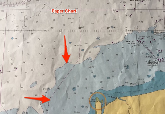
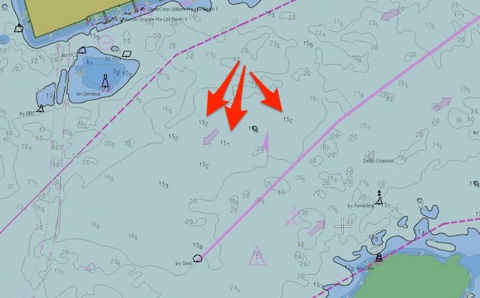
It is all in the name. Safety settings sets the safety parameters according to the ship’s static as well as dynamic particulars. That is a change ECDIS brought from the traditional paper charts. For example see this chart and I will ask one question.
Can we say that blue part on this chart is shallow water ?
It is and it is not. For a small vessel with less draft, it is not a shallow water. For a big container ship with deep draft, may be.
So you see, the colors on the paper chart may not represent the shallow waters for all the ships. But on the ECDIS these can be set by the user according to their draft and other parameters.
There are 4 safety settings
- Safety contour Setting
- Shallow contour settings
- Deep contour setting
- Safety Depth setting
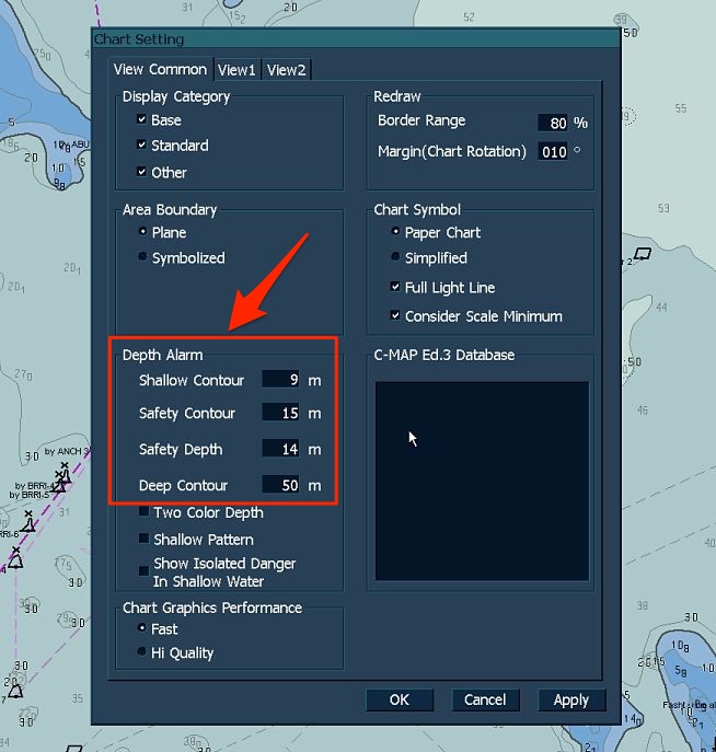
To enter a value for these settings on JRC ECDIS, go to
chart -> settings and then choose “S-57/C-Map/ARCS.
Now Let us discuss about these settings in detail and what values we need to enter in these settings
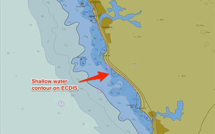
Shallow Contour setting
A contour is a line separating a minimum depth area. For example a 10 meter contour will be a line that separates waters below and above 10 meters depths.
The contours are in the value of 5, 10, 15, 20, 30 and so on.
Shallow contour value need to be used to tell ECDIS what is the value of shallow waters for our draft. This is the value of depth below which it is definite for the vessel to get aground.
The shallow contour value need to be equal to or more than the draft of the vessel.
Let us say the vessel’s draft is 9 meters and we enter the shallow contour value of 9 meter. The ECDIS will display 10 meter contour line as the shallow contour. If 10 meter contour is not available, it will take next contour as the shallow contour for the vessel.
The shallow contour lets the navigator know that between 0 meter depth and the shallow contour, the area is not navigable at all.
Safety Contour setting
Safety contour is the contour line above which we can navigate without any water depth concern.
So what is the depth of water required for the vessel to navigate without any concerns ? Off course it is the depth that complies with the company’s UKC policy.
Now again let us see it with an example. Vessel’s draft is 9 meters and at maximum speed, the expected squat is 1.1 meters. The company require the vessel to have UKC of 10% of the draft.
I assume you know the UKC calculation method and can easily arrive to the conclusion that this vessel would need 11 meters of water depth to navigate.
I have taken here the simplest of the case. In reality you need to follow your company’s UKC calculation sheet to arrive at the depths required to comply with UKC policy. This may take various factor such as sea conditions, increase in draft due to rolling, sea water density and the tide.
But the idea is to know the minimum depth of water at which you will comply with the company’s UKC policy.
This water depth becomes the safety contour setting. So if we enter 11 meters as safety contour setting, it will show 15 meter contour as the safety contour.
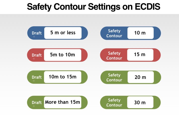
Some companies may give simpler instructions for the safety setting in the navigational manual. One form of these instruction can be based upon the draft of the vessel.
When safety contour value is entered in the ECDIS, it gives a safety contour line depths above which would meet the UKC requirement.
Safety Depth setting
So far we have only been talking about contours. We have not said anything about the actual safe depth. Safety depth is the only depth setting on ECDIS.
Safety depth is the depth of the water we can safely navigate upon. And it might sound repetitive but it is the depth that satisfies the UKC policy of the company.
In ECDIS we need to enter this minimum depth. It is same what we calculated as a simple example in safety contour setting. And as I said in that section, we need to follow the UKC calculation form of the company which may account for number of factors to calculate the safety depth required.
But the question is why do we need safety depth settings when we can navigate in waters above the safety contours ? This is because of two straight forward reasons
i) The depth above safety contour may not always be navigable.
This is in case of a shallow depth at one point in the navigable waters. Although we might be navigating in area above safety contour, this isolated depth pose a danger. Safety depth highlights this danger.
ii) The depths below safety contour may not always be non-navigable.
We can understand this If you allow me to again go through the safety contour value we entered. We entered the value of 11 meters and when we enter this value the ECDIS will take next available contour. This will be 15 meter contour.
Now the depths between 11 and 15 meters are navigable for us but it will show below the safety contour. So in the area between shallow contour and safety contour, safety depth will show the depth on which we can navigate.
Let us say we set the safety depth to 16 meters. On the ECDIS, all depths below 16 metes will be shown more prominently (in Black compared to others in grey color).
Deep water contour
This is a relative term and user is free to set as per what he believes could be deep water for him. For me deep water could be 50 meters while for others it could be 30 meters or 100 meters.
But there can be number of ways we can use the deep water contour setting.
For example you can set the deep water contour to show the maximum anchoring depths where vessel can drop anchor. So if your vessel can anchor maximum 105 meters depth, you can set the deep water contour to 100 meters.
Or if you are about to do ballast water exchange, you can set the deep water contour to 200 meters. This way you can easily see just by the color on the ECDIS if you are in depths where ballast exchange can be done.
The deep water contour setting can be used in number ways and navigators can use this to the way they wish to use it.
Differentiating the safety settings on ECDIS
Now let us see how the ECDIS screen will look like with all these settings. So let us say vessel’s draft is 9 meters and vessel require 14 meters depth to comply with company’s UKC policy.
So we have these settings
- Shallow contour: 9 meters
- Safety depth: 14 meters
- Safety Contour: 15 meters
- Deep Contour: 50 meters
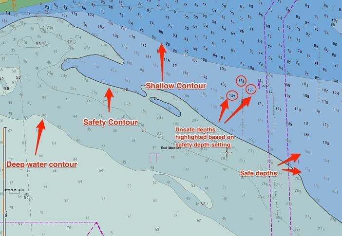
And when I enter all these numbers in the ECDIS, this is how a ECDIS screen would display these settings.
If you notice, for safety contour ECDIS has taken the 20 meter contour because 15 meter contour is not available.
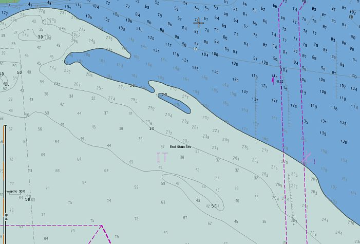
There is another option in the ECDIS to use two colors to show these areas. When this option is selected, following will happen
- Safety contour and deep contour will merge
- Shallow contour and safety contour will merge
Or we can say that light blue and blue color will merge and become blue. Same way, grey and white color will merge and become white.
So there will be only two colors. One to show the shallow waters and other to show the navigable water.
Even in the two color display, it is not that we cannot navigate in the shallow waters. This is because it is showing the contour and not the depth.
In our example, the dividing line will be the 15 meters contour. The area below this contour will show as shallow waters (blue color). But as the safety depth is 11 meters (which will be below 15 meters contour), we can navigate in the shallow waters provided the depth is above 14 meters.
Danger detection settings
Entering the safety settings will warn us with an alarm when vessel enters in shallow waters. But when it gives the alarm it could be too late by then.
Danger detection settings can help in giving pre-warning of the dangers ahead. We only need to define the area in which we need the ECDIS to warn us.
We can define the area in two ways
- Vector area
- Sector Area
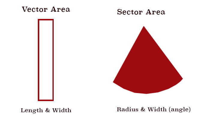
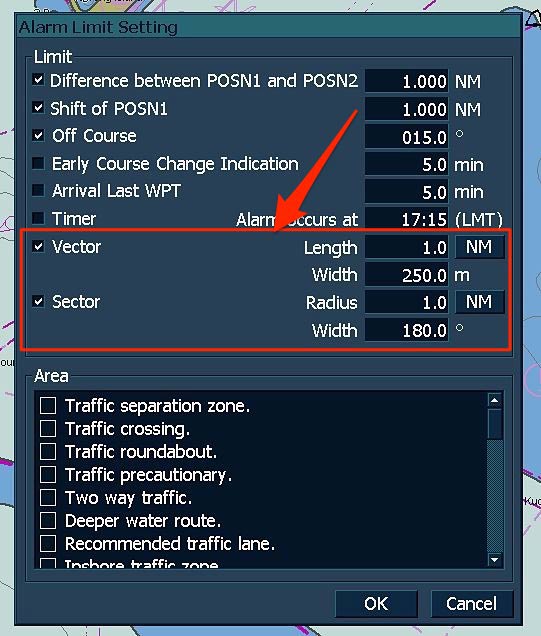
Vector area defines the area in length and width. Sector area defines the area in radius and width (angle).
Vector area defines the area in length and width. Sector area defines the area in radius and width (angle).
Let us define this area on JRC ECDIS. On JRC ECDIS go to Menu, Settings and then choose Alarm settings.
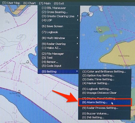 This will open the Alarm settings pane.
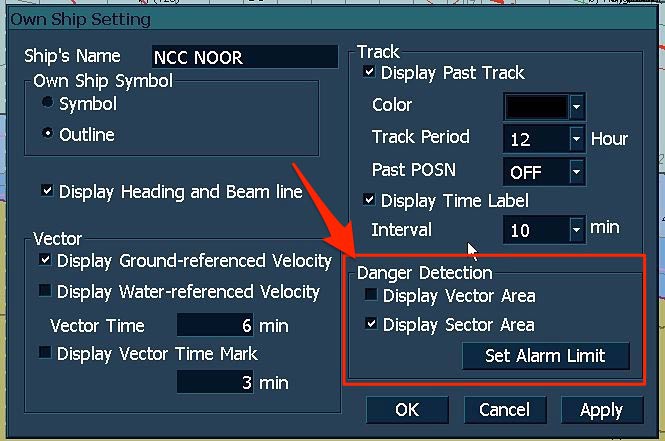
Under Vector and Sector section, you can define the area you want the ECDIS to look ahead. Once these areas are defined you can turn these on by going to “Ownship/Track” and then choosing “Settings”.
You can then choose to either “Vector area” or “Sector area”. You can even go to alarm settings page by clicking on “Set alarm limit” from danger detection section.
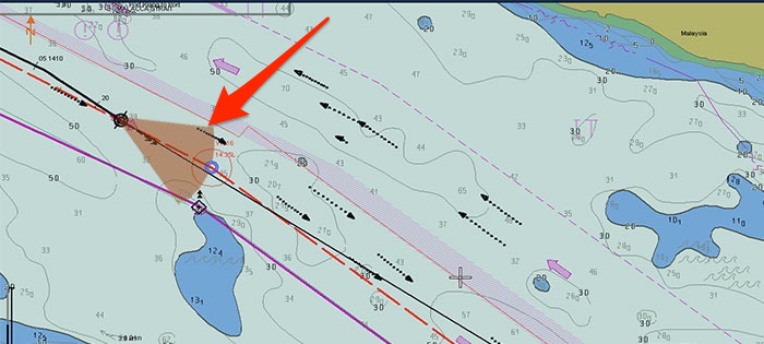
When you choose to display “Sector area”, it will look like this and ECDIS will trigger alarm if it detects any danger in this area.
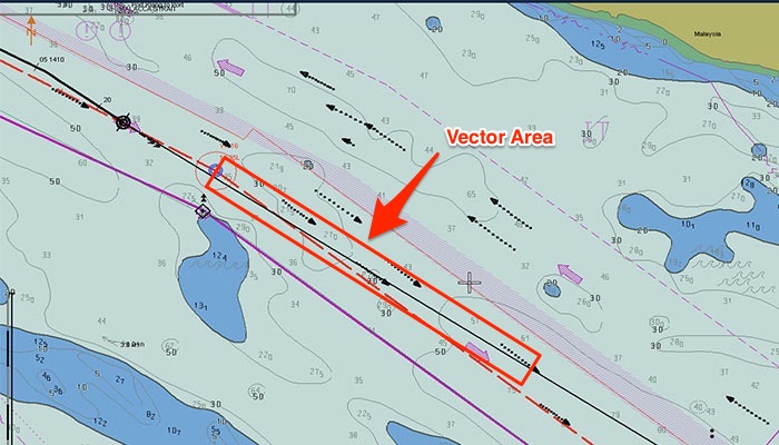
When you choose to display “Vector area”, it will look like this and ECDIS will trigger alarm if it detects any danger in this area.
Alarm Buzzer settings
I have talked about different safety settings on ECDIS. But these settings are of no use if do not have the alarm buzzer volume on. If the volume of the buzzer is off, ECDIS would not be able to alert the navigator.
But there are times when we need to keep the buzzer off. Like in high traffic density area when we are constantly monitoring the traffic. In this case frequent alarms will be of lesser value.
Navigators must use their professional competence to decide when they need to turn on the alarm buzzer.
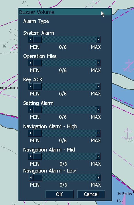
On JRC ECDIS to turn on the volume of the alarm buzzer, go to “Main”, “Setting” and then choose “buzzer volume”.
This will open a pane from where you can increase or decrease the volume of different type of alerts.
Conclusion
I am a big advocate of use of ECDIS on board for navigation. In my opinion ECDIS is making the shipping safer. Sure there have been number of incidents because of user’s interpretation of ECDIS display but the increase in training and good practices has helped to cover many gaps. Correct use of safety settings in ECDIS will definitely take it one step ahead .
Knowledge of what these safety settings mean can help in that.
Share this:

About Capt Rajeev Jassal
Capt. Rajeev Jassal has sailed for over 24 years mainly on crude oil, product and chemical tankers. He holds MBA in shipping & Logistics degree from London. He has done extensive research on quantitatively measuring Safety culture onboard and safety climate ashore which he believes is the most important element for safer shipping.
Search Blog
80 Comments


Sir,thanks for the post,very clearly explained abt the depth settings,Requesting more info on Ecdis.

Thank you Muthukkumaran. There are couple of posts on ECDIS. Check them out if these can be of some help.

sir can u tell, technical difference between rescue boat and lifeboat (if using lifeboat as rescue boat) except the hoisting requirement.

Rescue boat has recovery stropes to recover the lifeboat in heavy weather.

Excellent information. Explained in a very simple and easy to understand manner. Keep it up.

Thanks bro.. Glad to have you as regular reader..

Good day sir.Thank you very much for passing important informations .I found it very helpful.i wish u to keep writing blogs.It touched my heart the way u are helping others with your vast knowledge.Thank u once again sir.

Thanks for your kind words Abbas..

Good Day Sir.. It would be very great if you could explain about the isolated danger symbol in shallow waters as they are also a very handy tool for anti grounding alarm in Ecdis.

I will try to cover in one of the future blog Aswini..

Isolated dangers are automatically shown above safety contour i.e. in safe waters. However, they can also be seen below safety contours provided you select feature ''Isolated dangers in shallow water'' in few ECDIS

Sir, I think it is the funciton of safety contour , instead of your mentioned safety depty. and further more compared with chart example , the safety depth setting should be 14 meters in your example of "Differentiating the safety settings on ECDIS " - This is in case of a shallow depth at one point in the navigable waters. Although we might be navigating in area above safety contour, this isolated depth pose a danger. "Safety depth highlights this danger." tks.

I think that is exactly what I said in this article.. But if you read under "Safety depth setting" I have explained why safety depth is taken as 11 meters in this case.

But as the safety depth is 11 meters (which will be below 15 meters contour), we can navigate in the shallow waters provided the depth is above 14 meters. sir i beleive there has been a typo in the above sentence..it should be ""safety depth is 14 meters"" instead of 11...correct me if i am wrong

Good day. Found this quite informative. Just a doubt. In general we keep the safety depth n contour values same. But in any other case safety depth can be greater than the contour values?

Yes, it can be the case where safety depth can be more than safety contour. However, u have to mark the no go area manually similar to paper charts because there will be unsafe waters when following the above water which will be not subjected to further alarms.

Great job. Thanks. Can the post be done in downloadable way?

I will try to include that fucntionality in near future..

Very well explained. What about the ports where the tidal range is high as 4-5 m? For example An aframax vessel of 12.5 m and Depth of channel is 13.6 m. Tide at the time of transit = 4.5 m so what would be ideal setting on ECDIS???

In this case you need to do the calculation basis what charted depth is safe for you. For example if with 12.5 m draft and with all the requirements (Company minimum UKC and squat etc) you require water depth of 14.5 meters. You need to remove the height of tide from it. That means the safety depth to be entered in ECDIS becomes 10 meters. Same method of calculation goes with other settings.

Sir, I have query regarding shallow contour settings in tidal ports havin 4-5 mtrs of tide for a particular window let say about 10 NM which requires minimum 4 mtrs of tide and the channel is about 50 NM. In this case what should be the settings of Safety depth / contour and shallow contour. Do i need to change ECDIS PARAMETERS again and again for different tidal range or same?? Let say my draft is 10.25 mtr EK and after applying squat and minimum UKC requirement from company my safety depth settings for pilotage waters becomes 13.37 mtrs (Speed 10 knts - squat - 2.62) and minimum UKC 0.5 mtrs. Here what tide to take to calculate my settings because its a 5 hours passage and tide is changing frequently and as i mentioned above for last 10 NM i need minimum 4 mtrs of tide. Can you please clarify? ECDIS parameters settings for sfety depth / contour and shallow contour. Will be highly obliged.

Sir, I would really appreciate your assistance if you please reply to my query asked in the above comment on my email id!

Let me know if you have any other doubt..

Thank you so much for your blog on safety settings in ecdis.it was really very useful.i had one doubt , is it ok to enter higher values in safety settings or else we should put the exact value which we get from calculation. can inspectors ask us ,that why you have entered little higher values? Thanks

Yes you can put higher values as long as you do not sail on danger depths for these higher values. For example if your safety depth is 10 meters and you put a higher safety depth value of 20 meters. Now if have sailed over 15 meter depth (unsafe as per safety settings but safe in real) then it will be considered as a matter of concern because you will no longer be able to distinguish between safe and unsafe depths. But if you are following those higher value of settings, like in this case you actually want to be in depths over 20 meters, you can do that and no one should question these higher safety setting values.

Tysm sir for your reply..

Sarthak Vohra 2 mins ago Sir, I have query regarding shallow contour settings in tidal ports havin 4-5 mtrs of tide for a particular window let say about 10 NM which requires minimum 4 mtrs of tide and the channel is about 50 NM. In this case what should be the settings of Safety depth / contour and shallow contour. Do i need to change ECDIS PARAMETERS again and again for different tidal range or same?? Let say my draft is 10.25 mtr EK and after applying squat and minimum UKC requirement from company my safety depth settings for pilotage waters becomes 13.37 mtrs (Speed 10 knts - squat - 2.62) and minimum UKC 0.5 mtrs. Here what tide to take to calculate my settings because its a 5 hours passage and tide is changing frequently and as i mentioned above for last 10 NM i need minimum 4 mtrs of tide. Can you please clarify? ECDIS parameters settings for sfety depth / contour and shallow contour. Will be highly obliged.

In this case you either you need to change the settings again and again or you can just calculate and ensure that you have sufficient UKC and keep the same settings. This is a particular situation but the idea is that we need to be sure of our UKC and in this case we need to be very attentive as the information could be misleading.

Hi sir, it's a great article. i've referred to many ECDIS Articles before Venturing into yours, couldn't help noticing most of those article said Deep Contour is to indicate the waters upon which a vessel experience squat, well it doesn't make any sense because Deep contour is twice the ship's deepest draft and safety contour(indicates safe waters) is ship's draft+Squat+UKC+CATZOC, which is obviously lower value than deep contour. So when a vessel sailing in safety contour would not squat let alone aground* but she will experience squat in Deep contour??. To put that in perspective a vessel could exp squat in deep contours , when she sails towards safety contours only to experience more or much worse!! . Maybe I've gotten it all wrong !! Pls correct me if i'm wrong.

You are right Nish..

Gud day Captain! can you kindly give me your opinion about these formula which I got from an NK surveyor in Brisbane. Safety contour = (Draft + UKC) - Height of tide and, Safety Depth = (Draft + Squat + safety (as per company)) - Height of tide. thanks for replying, God bless.

It is right about Safety Depth but safety contour will be same as safety depth as it automatically takes the next available contour.

SIR SIMPLY SUPER,VERY HELPFUL,U HAVE VAST KNOWLEDGE ON DIFFERENT TOPICS,THANK U VERY MUCH

Thank you for being a reader ..

Thanks for this post,.

Thank you for reading Buenfil...

Oh I just finish Ecdis course over here without spending Single Penny. Many thanks Capt. Rajeev Jassal . You are doing great job.

Glad to hear that Sandeep...

Nice Explanation sir. Can you explain about Limiting Danger Line (LDL) in detail sir.

Sir can you help about confirmation display of ECDIS Chart1 (PL4.0) for ECDIS JRC JAN-901B, procedure how to demonstrate.

How to check CATZOC on JRC ECDIS 901B, plz comment ...!!

Thanks sir for sharing ideas

Thanks Moi...

Thanks a lot. Im preparing for my masters in uk. Your article did helpe me and im sure will help a lot of people in the future too . Keep up your hardwork.

Glad you found it helpful Arvind...

Hi Capt. Jassal, I have not read your entire article - going no further than: "To enter a value for these settings on JRC ECDIS, go to chart -> settings and then choose “S-57/C-Map/ARCS." My comment is about 'ARCS' - Admiralty Raster Chart Service; I think in this regard a little more clarity is required in your article. It is pointless to set Safety Contours etc on Raster Charts - the contour alarms won't work in RCDS Mode. Many thanks

Hi Ivor, that option is the only option in JRC ECDIS for entering the safety settings. When I wrote “choose S-57/C-Maps/ARCS”, I am only highlighting the option to choose to set the safety settings and I am not implying that it will work on Raster charts.

Very easy to understand practically from now....Thanks and keep writing good stuff.... Please start utube videos also....As there is very limited stuff in utube.

Thank you so much for sharing your in depth knowledge on various topics. Its really of great help as well as clearing up ambiguities.

Awesome, Thank you so much for sharing such an awesome blog... boat safety alert services boat recall alerts

Hi, Capt your blog is very informative for me. I appreciate all your hard working for this article. Thank you so much for this.

Nice job,many thanks.

VERY HELPFUL..NICELY ELABORATED..

Very helpful article.

Hello sir.,your article was very useful..written in very simple language to understand ecdis so nicely., thank you. I have doubth about overlapping of chart. Can u pls help me with it. How do I separate it? Or transfer my course while passage plan. It was asked by surveyors in MMD.

Sir can you pls explain, on which shade (Two colour or Four colour), it is safe to navigate.

Thanks sir, very useful

Thankyou sir for useful information Sir some books says safety depth= draft+ukc+squat-hight of tide Sir in ports like mundra where tide is more than 7-8 m how it ll give good result. Assume my draft is 8 m 2m ukc nd 2 m squat HOT is 8 m So Safety depth= 8+2+2-8= 4m How its possible. And not one book But all books saying same formulla Plz guide regarding this.

good day sir, could u pls shed some light about the limitations of using ECDIS in RCDS mode. and how is the display change in RCDS mode in JRC 901 b ECDIS

You have great knowledge. Thank you sir

Good day captain! thank you very much for sharing your great knowledge.

Good Explanation indeed, However I have a question below. On what basis you will set your look ahead sectors?

Good day. Are there any regulations for standard setting of guard zone (vector/sector) coverage? Thanks

Sir which alarms on ecdis we can not turn off?

Capt. Thank you for your tips its very useful for all seafarers

Dear sir My querry regarding t n p on Ecdis as t n p is automatic updated in ecdis on weekly basis with enc update , but if the surveyor ask show me the latest t n p on ecdis,how i should go about it pls explain ..

Thank you so much for sharing your in depth knowledge.My doubt is when will ECDIS look ahead feature show wrong reading?

Your a legend the way you explained...gifted... matsalam

Thank you Capt Rajeev a very nice explaination. I hope next also for tokyo keiki ECDIS

Dear Capt, You are the google of global seafarer society.Kindly elaborate about the static draft and dynamic draft on your words.Thank you sir.

Sir what is the importance of proper srtting-upof ECDIS safety display atleast 5 example.

Hey There. I found your blog using msn. This is a very well written article on health and safety.I will make sure to bookmark it and return to read more oof your useful info. Thanks for the post. I’ll certain comeback.

Sir good day, Why there depths are displayed in bolt and normal figure in tha waters with less than displayed Safety Contour?

Assalamualaikum. Well-done sir. Would you give me JRC ECDIS manual on the basis of your answer?

What is the best setting of shallow contour? same as max draft? or should be set at the closest available contour, even if this contour is less than the vessel draft.

Please could you explain how to calculate anti-grounding cone for vsl?
Leave Comment
More things to do on myseatime
MySeaTime Blogs
Learn the difficult concepts of sailing described in a easy and story-telling way. These detailed and well researched articles provides value reading for all ranks.
Seafarers Question Answers
Ask or answer a question on this forum. Knowledge dies if it remains in our head. Share your knowledge by writing answers to the question

MySeaTime Podcast
This podcast on the maritime matters will provide value to the listeners. Short, crisp and full of value. Stay tuned for this section.

Sir please elobrate abt cat zoc zones
Categories of Zone of confidence (CATZOC) in a way tells us how accurate the data on the ENCs is. These are divided in different zones like A1 has the depth accuracy of 1% and C has accuracy of 5%. It all reminds us to take extra safety margins. I will try to cover in detail on future posts.
CATZOCs are increasingly important, in the absence of source data diagrams, to inform mariners about the reliability of the survey data that forms the charts. This is very important check during the passage plan. if you ignore ,may lead to grounding.
Captain Rajeev please can u tell us what about on sperry ecdis,we do have vector area for detwction pf dangerous, but is there for sector detection? thanks